| . |  |
. |
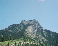
New York NY (SPX) May 17, 2006 "The mountains skipped like rams..."- Psalm 114. "Moving mountains" has come to mean doing the impossible. Yet at least once in the past, one mountain relocated a fair distance away. This feat took place around 50 million years ago, in the area of the present-day border between Montana and Wyoming. Heart Mountain was part of a larger mountain range when the 100 km (62 mile) long ridge somehow became detached from its position and shifted about 100 km to the southwest. This "migrating mountain" has garnered interest from geologists and geophysicists around the world who have tried to solve the mystery behind the largest known instance of land movement on the face of any continent. Dr. Einat Aharonov of the Weizmann Institute's Environmental Sciences and Energy Research Department, working in collaboration with Dr. Mark Anders of Columbia University in New York, recently published a paper in the scientific journal Geology that offers an explanation for the phenomenon. Aharonov and Ander's explanation is based on dikes - vertical cracks in the rock that fill with hot lava boiling up from deep in the earth. In Heart Mountain, these dikes formed a passage for the lava, three kilometers deep, through the limestone aquifer (a porous, water-soaked layer). There, the sizzling lava would have heated the water to extreme temperatures, causing tremendous fluid pressures. The scientists developed a mathematical model (based on the number of dikes in the mountain and their structure) that allowed them to calculate the temperatures and pressures that would have been created deep within the base of the mountain. The results showed that the infiltrating hot lava would have turned the water in the aquifer layer into a sort of giant pressure cooker, releasing enough force to move Heart Mountain from its original spot to its present site. Related Links American Committee for the Weizmann Institute of Science  Seattle WA (SPX) May 04, 2006
For many years geologists have harbored a belief that the Kamchatka Peninsula, shrouded in mystery and secrecy on Russia's east coast, actually sits on the same tectonic plate as the mainland United States, Canada and Mexico. The North America plate extends through Alaska across the Bering Strait and into Siberia, but the question is whether it reaches as far south as Kamchatka. |
|
| The content herein, unless otherwise known to be public domain, are Copyright 1995-2006 - SpaceDaily.AFP and UPI Wire Stories are copyright Agence France-Presse and United Press International. ESA PortalReports are copyright European Space Agency. All NASA sourced material is public domain. Additionalcopyrights may apply in whole or part to other bona fide parties. Advertising does not imply endorsement,agreement or approval of any opinions, statements or information provided by SpaceDaily on any Web page published or hosted by SpaceDaily. Privacy Statement |