| . |  |
. |
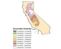
Pasadena CA (SPX) Dec 21, 2009 New space observations reveal that since October 2003, the aquifers for California's primary agricultural region - the Central Valley - and its major mountain water source - the Sierra Nevadas - have lost nearly enough water combined to fill Lake Mead, America's largest reservoir. The findings, based on data from the NASA/German Aerospace Center Gravity Recovery and Climate Experiment (Grace), reflect California's extended drought and increased rates of groundwater being pumped for human uses, such as irrigation. In research being presented this week at the American Geophysical Union meeting in San Francisco, scientists from NASA and the University of California, Irvine, detailed California's groundwater changes and outlined Grace-based research on other global aquifers. The twin Grace satellites monitor tiny month-to-month changes in Earth's gravity field primarily caused by the movement of water in Earth's land, ocean, ice and atmosphere reservoirs. Grace's ability to directly 'weigh' changes in water content provides new insights into how Earth's water cycle may be changing. Combined, California's Sacramento and San Joaquin drainage basins have shed more than 30 cubic kilometers of water since late 2003, said professor Jay Famiglietti of the University of California, Irvine. A cubic kilometer is about 264.2 billion gallons, enough to fill 400,000 Olympic-size pools. The bulk of the loss occurred in California's agricultural Central Valley. The Central Valley receives its irrigation from a combination of groundwater pumped from wells and surface water diverted from elsewhere. "Grace data reveal groundwater in these basins is being pumped for irrigation at rates that are not sustainable if current trends continue," Famiglietti said. "This is leading to declining water tables, water shortages, decreasing crop sizes and continued land subsidence. The findings have major implications for the U.S. economy, as California's Central Valley is home to one sixth of all U.S. irrigated land, and the state leads the nation in agricultural production and exports." "By providing data on large-scale groundwater depletion rates, Grace can help California water managers make informed decisions about allocating water resources," said Grace Project Scientist Michael Watkins of NASA's Jet Propulsion Laboratory, Pasadena, Calif., which manages the mission for NASA's Science Mission Directorate, Washington. Preliminary studies show most of the water loss is coming from the more southerly located San Joaquin basin, which gets less precipitation than the Sacramento River basin farther north. Initial results suggest the Sacramento River basin is losing about 2 cubic kilometers of water a year. Surface water losses account for half of this, while groundwater losses in the northern Central Valley add another 0.6 cubic kilometers annually. The San Joaquin Basin is losing 3.5 cubic kilometers a year. Of this, more than 75 percent is the result of groundwater pumping in the southern Central Valley, primarily to irrigate crops. Famiglietti said recent California legislation decreasing the allocation of surface waters to the San Joaquin Basin is likely to further increase the region's reliance on groundwater for irrigation. "This suggests the decreasing groundwater storage trends seen by Grace will continue for the foreseeable future," he said. The California results come just months after a team of hydrologists led by Matt Rodell of NASA's Goddard Space Flight Center, Greenbelt, Md., found groundwater levels in northwest India have declined by 17.7 cubic kilometers per year over the past decade, a loss due almost entirely to pumping and consumption of groundwater by humans. "California and India are just two of many regions around the world where Grace data are being used to study droughts, which can have devastating impacts on societies and cost the U.S. economy $6 to $8 billion annually," said Rodell. Other regions under study include Australia, the Middle East - North Africa region and the southeastern United States, where Grace clearly captured the evolution of an extended drought that ended this spring. In the Middle East - North Africa region, Rodell is leading an effort to use Grace and other data to systematically map water- and weather-related variables to help assess regional water resources. Rodell added Grace may also help predict droughts, since it can identify pre-existing conditions favorable to the start of a drought, such as a deficit of water deep below the ground. Share This Article With Planet Earth
Related Links NASA/German Aerospace Center Gravity Recovery and Climate Experiment (Grace) Water News - Science, Technology and Politics
 Huge sewage lake threatens flood-hit Jeddah
Jeddah, Saudi Arabia (AFP) Dec 17, 2009 Weeks after a devastating flash flood, residents of Jeddah fear that further heavy rainfall could bring a huge, brimming reservoir of raw sewage cascading onto Saudi Arabia's Red Sea capital. Until the November 25 flood submerged homes and roads, killing at least 120 people, every day a line of tanker trucks made their way from Jeddah, a city of 2.6 million with almost no municipal sewerage ... read more |
|
| The content herein, unless otherwise known to be public domain, are Copyright 1995-2009 - SpaceDaily. AFP and UPI Wire Stories are copyright Agence France-Presse and United Press International. ESA Portal Reports are copyright European Space Agency. All NASA sourced material is public domain. Additional copyrights may apply in whole or part to other bona fide parties. Advertising does not imply endorsement,agreement or approval of any opinions, statements or information provided by SpaceDaily on any Web page published or hosted by SpaceDaily. Privacy Statement |
 del.icio.us
 Digg
Digg Reddit
 YahooMyWeb
 Google