| . |  |
. |
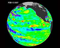
Pasadena CA (JPL) Mar 08, 2007 New data of sea-level heights from early February, 2007, by the Jason altimetric satellite show that the tropical Pacific Ocean has transitioned from a warm (El Nino) to a cool (La Nina) condition during the prior two months. The beginnings of a possible La Nina are indicated by the blue area (in the center of the image along the equator) of lower than normal sea level (cold water). It is not certain yet if this current cooling trend will eventually evolve into a long-lasting, well-developed La Nina. "La Nina could send an already parched Western United States to its knees," said JPL oceanographer Dr. Bill Patzert. "In the Southwest, we call La Nina the little lady with the big dry punch." A La Nina situation often follows an El Nino episode and is essentially the opposite of an El Nino condition. During a La Nina, trade winds are stronger than normal, and the cold water that normally exists along the coast of South America extends to the central equatorial Pacific. A La Nina situation changes global weather patterns and is associated with less moisture in the air, resulting in less rain along the coasts of North and South America. Jason will continue to track this developing switch in the climate. This image of the Pacific Ocean was produced using sea-surface height measurements taken by the U.S.-French Jason satellite. The image is based on the average of 10 days of data centered on February 12, 2007, compared to the long-term average of observations from 1993 through 2005. In this image, places where the Pacific sea surface height is higher (warmer) than normal are yellow and red, and places where the sea surface is lower (cooler) than normal are blue and purple. Green shows where conditions are near normal. Sea-surface height is an indicator of the heat content of the upper ocean. NASA's Jet Propulsion Laboratory manages the U.S. portion of the U.S./French Jason mission for NASA's Science Mission Directorate, Washington, D.C. JPL is a division of the California Institute of Technology, Pasadena, Calif.
earlier related report Nino is an abnormal warming of surface ocean waters in the eastern tropical Pacific, which often brings significant shifts in global weather patterns. As rainfall sharply decreased during the last quarter of 2006 across the dense tropical rainforests of Sumatra, Kalimantan, and Malaysia, the land became exceptionally dry. This allowed wildfires to quickly spread, releasing large amounts of soot and tiny dust particles called aerosols that brought unhealthy pollution levels to the area. The Measurements of Pollution in the Troposphere (MOPITT) instrument aboard NASA's Terra satellite tracked the wildfire pollution plumes as they spread from the Indonesian islands into the Indian Ocean from September through November 2006, and measured the associated increases in atmospheric carbon monoxide levels. "Droughts over Indonesia are often brought on by a shift in the atmospheric circulation over the tropical Pacific associated with El Nino conditions," said David Edwards, MOPITT project leader at the National Center for Atmospheric Research, Boulder, Colo. "Although the current El Nino is rather weak compared to that of 1997-98, we have found dramatic increases in wildfire activity and corresponding pollution." Using MOPITT, Edwards and his team noted a distinct spike in carbon monoxide levels across much of the Southern Hemisphere from the large number of Indonesian fires at the end of 2006, greater than that associated with any El Nino event since 1997-98. The recent increase in wildfires was also captured by another instrument, the Moderate Resolution Imaging Spectroradiometer, on NASA's Terra and Aqua satellites, while NASA's Global Precipitation Climatology Project confirmed a decline in Indonesian rainfall during the period. Despite the number of factors that influence air quality across the region, wildfires play a very significant role. "Even though fires in South America and southern Africa typically produce the greatest amount of carbon monoxide, the pollution from Indonesian fires is likely responsible for most of the year-to-year variation in pollution levels throughout the Southern Hemisphere," Edwards said. Carbon monoxide is also involved in raising the concentration of ground-level "bad" ozone. Some burning takes place every year in Indonesia, but the number and intensity of fires depends largely on rainfall and soil moisture conditions during the fire season, which usually runs September through November. Regional forest clearing practices also heighten the risk for wildfire development and spread. As lands are cleared, peat deposits - thick layers of partially decayed vegetation matter - build up. These deposits are vulnerable to wildfire and once ignited often result in a smoldering burn that releases copious amounts of smoke and carbon into the atmosphere until monsoon rains begin, typically in December. "MOPITT is an especially valuable tool because it monitors carbon monoxide, a good indicator of pollution from combustion that remains in the atmosphere for several weeks, often traveling vast distances," said Edwards. "Fires also produce large relative changes in atmospheric carbon monoxide levels that are detected quite well by satellites, so that we can easily assess the impact of fires on air quality and pollution levels." Carbon monoxide released from wildfires is a major player in regional air quality conditions, but significant amounts of carbon dioxide - the primary greenhouse gas - are also released. As a result, wildfires also have the potential to impact long-term climate. The scientists are currently studying how they can use satellite data to examine Northern Hemisphere wildfire outbreaks and corresponding pollution increases due to periodic changes in weather patterns. Email This Article
Related Links  Auburn, AL (SPX) Mar 08, 2007
An Auburn University chemistry professor's research is leading to safer drinking water in India through advanced, longer-lasting water filters. Professor Dave Worley's N-halamine technology is the basis for the in-home filters that HaloSource Inc. introduced March 1 in Bombay, India. The company, established in 1998 on the potential of Worley's discoveries, pays royalties to the university through a technology transfer agreement. |
|
| The content herein, unless otherwise known to be public domain, are Copyright 1995-2006 - SpaceDaily.AFP and UPI Wire Stories are copyright Agence France-Presse and United Press International. ESA PortalReports are copyright European Space Agency. All NASA sourced material is public domain. Additionalcopyrights may apply in whole or part to other bona fide parties. Advertising does not imply endorsement,agreement or approval of any opinions, statements or information provided by SpaceDaily on any Web page published or hosted by SpaceDaily. Privacy Statement |