| . |  |
. |
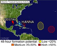
Greenbelt MD (SPX) Sep 01, 2008 Tropical Storm Hanna is keeping forecasters on their toes. On Friday, Aug 29, she seemed headed toward the U.S. East Coast. On Saturday, it appeared a high pressure system that is intensifying may shoot her into the Gulf of Mexico. On Sunday, it appears that high may be moving enough and not strengthening enough to push her Gulf-ward and allow her to move toward the U.S. East Coast. She appears now to be on a short-term track through the Bahamas, Turks and Caicos.
Lots of Meteorological Factors Come into Hanna's Track According to the National Hurricane Center discussion, "nearly all of the (computer forecast) models forecast the strong upper-trough to lift out to the Northeast and be replaced by a large ridge to the north and east of Hanna. The latter feature is expected to gradually induce a northwestward component of motion by days 4 and 5. The key to the forecast track at those forecast times will be just how far south and west Hanna moves before it begins to move northwestward. The bottom line is that everyone in the southeast U.S. coastal areas needs to be on guard for Hanna. Not only for her possible approach, but for dangerous rip currents that she will be creating over the next several days along U.S. east coast beaches. At 8:00 a.m. EDT, Hanna's maximum sustained winds are near 60 mph with higher gusts. Little change in strength is expected during the next couple of days. Hanna's center was located about 155 miles northeast of Grand Turk Island, near latitude 23.2 north and longitude 69.5 west. She's moving west-northwest near 12 mph, taking her north of the Turks and Caicos Islands later today and tonight. Estimated minimum central pressure is 999 millibars. Community Email This Article Comment On This Article Share This Article With Planet Earth
Related Links National Hurricane Center Tropical Rainfall Measuring Mission Bringing Order To A World Of Disasters When the Earth Quakes A world of storm and tempest
 New Orleans, Louisiana (AFP) Aug 31, 2008
More than a million people fled Louisiana as killer Hurricane Gustav on Sunday roared toward New Orleans, a fragile US coastal city still deeply scarred by the devastating 2005 Katrina storm. |
|
| The content herein, unless otherwise known to be public domain, are Copyright 1995-2007 - SpaceDaily.AFP and UPI Wire Stories are copyright Agence France-Presse and United Press International. ESA Portal Reports are copyright European Space Agency. All NASA sourced material is public domain. Additional copyrights may apply in whole or part to other bona fide parties. Advertising does not imply endorsement,agreement or approval of any opinions, statements or information provided by SpaceDaily on any Web page published or hosted by SpaceDaily. Privacy Statement |
 del.icio.us
 Digg
Digg Reddit
 YahooMyWeb
 Google