| . |  |
. |
Space Imaging announced Wednesday it will soon offer satellite ground station access and sell imagery from Indian Space Research Organization's (ISRO) newest satellite Cartosat-1 (P-5). Space Imaging has an exclusive sales and marketing agreement through 2010 with Antrix, a division of the ISRO, which covers worldwide rights to sell imagery outside of India. The agreement covers sale of imagery and direct ground station access to the Cartosat-1, Resourcesat-1 and the Indian Remote Sensing (IRS) 1-C and 1-D satellites. ISRO says Cartosat-1 is scheduled to be launched on May 5. ISRO's Polar Satellite Launch Vehicle, PSLV-C6, will launch India's latest remote sensing satellite into a 618-km, polar sun-synchronous orbit. It will be launched from India's newest launch pad (Second Launch Pad) at the Satish Dhawan Space Centre (SDSC). Cartosat-1 has two state-of-the-art panchromatic cameras that take black- and-white stereoscopic images in the visible light spectrum at a resolution of 2. 5 meters. The cameras cover a swath of about 30 km and take images of the same area during the same pass from two different angles. The stereo images can be used to create accurate elevation data of the Earth and create three- dimensional image maps. Since the cameras are steerable, Cartosat-1 has a revisit time over any part of the Earth every five days. Cartosat-1 also has an onboard storage capacity of 120 Giga Bits to store images when not in contact with a ground station. "Both Cartosat-1 and Resourcesat-1 show the prominence the Indian commercial program has around the world," said Robert Dalal, CEO of Space Imaging. "Cartosat-1 will soon become a well-known resource in the global Earth-observation market, and Space Imaging and Antrix together will lead its adoption and growth. Data from Cartosat-1 will be used for large-scale mapping, urban and rural development, land and water resources management, disaster assessment, relief planning and management, environmental impact assessment and various other geospatial and mapping applications. The data is also ideal for updating topographic maps. To commemorate the launch of Cartosat-1, Space Imaging is releasing a new IKONOS satellite image of the Second Launch Pad at the Satish Dhawan Space Centre where Cartosat-1 will be launched. Related Links Space Imaging ISRO TerraDaily Search TerraDaily Subscribe To TerraDaily Express 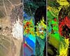 Washington (SPX) May 04, 2005
Can you see the difference between traditional corn and bio-engineered corn? NASA technology is beginning to provide the answer in a snapshot. The technology is called hyperspectral imaging. |
|
| The content herein, unless otherwise known to be public domain, are Copyright 1995-2016 - Space Media Network. All websites are published in Australia and are solely subject to Australian law and governed by Fair Use principals for news reporting and research purposes. AFP, UPI and IANS news wire stories are copyright Agence France-Presse, United Press International and Indo-Asia News Service. ESA news reports are copyright European Space Agency. All NASA sourced material is public domain. Additional copyrights may apply in whole or part to other bona fide parties. Advertising does not imply endorsement, agreement or approval of any opinions, statements or information provided by Space Media Network on any Web page published or hosted by Space Media Network. Privacy Statement All images and articles appearing on Space Media Network have been edited or digitally altered in some way. Any requests to remove copyright material will be acted upon in a timely and appropriate manner. Any attempt to extort money from Space Media Network will be ignored and reported to Australian Law Enforcement Agencies as a potential case of financial fraud involving the use of a telephonic carriage device or postal service. |