| . |  |
. |
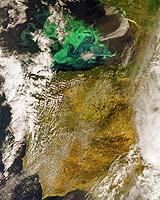
A break in the clouds in an Envisat observation of the west coast of Europe last week revealed a striking marine phytoplankton bloom currently dominating the Bay of Biscay. Phytoplankton are microscopic marine plants that drift on or near the surface of the sea, by far the most abundant type of life found in the ocean. Just like plants on land they employ green-pigmented chlorophyll for photosynthesis - the process of turning sunlight into chemical energy. While individually microscopic, phytoplankton chlorophyll collectively tints the surrounding ocean waters, providing a means of detecting these tiny organisms from space with dedicated 'ocean colour' sensors. As if dye had been placed in the water, the greenish colour highlights whirls of ocean currents. Floating freely in the water, phytoplankton are sensitive not just to available sunlight but also to local environmental variations such as nutrient levels, temperature, currents and winds. Favourable conditions lead to concentrated 'blooms' like the one we see here. Monitoring phytoplankton is important because they form the base of the marine food web � sometimes known as 'the grass of the sea'. On a local level, out-of-control blooms can devastate marine life, de-oxygenating whole stretches of water, while some species of phytoplankton and marine algae are toxic to both fish and humans. It is useful that fishermen, fish farmers and public health officials know about such events as soon as possible. Globally, phytoplankton are a major influence on the amount of carbon in the atmosphere, and hence need to be modelled into calculations of future climate change. Phytoplankton blooms occur frequently at this time of year in the Bay of Biscay. This 'spring bloom' takes place as cold, nutrient-rich waters are finally exposed to sufficient sunlight to trigger rapid phytoplankton growth. The bloom is signaling a new cycle of biological production, important for the local fishing industry - the Bay of Biscay being a rich fishery. Envisat's Medium Resolution Imaging Spectrometer (MERIS) instrument is optimised for ocean colour detection, but also returns detailed multispectral information on land cover, clouds and atmospheric aerosols. MERIS acquires continuous daytime observations in Reduced Resolution mode as part of its background mission. This MERIS Reduced Resolution image was acquired on 2 May 2005. The full version (see photo caption) has a spatial resolution of 1200 metres and covers an area of 838 by 2277 km. Related Links TerraDaily Search TerraDaily Subscribe To TerraDaily Express  Jena, Germany (ESA) May 06, 2005
The most detailed portrait ever of the Earth's land surface is being created with ESA's Envisat environmental satellite. |
|
| The content herein, unless otherwise known to be public domain, are Copyright 1995-2016 - Space Media Network. All websites are published in Australia and are solely subject to Australian law and governed by Fair Use principals for news reporting and research purposes. AFP, UPI and IANS news wire stories are copyright Agence France-Presse, United Press International and Indo-Asia News Service. ESA news reports are copyright European Space Agency. All NASA sourced material is public domain. Additional copyrights may apply in whole or part to other bona fide parties. Advertising does not imply endorsement, agreement or approval of any opinions, statements or information provided by Space Media Network on any Web page published or hosted by Space Media Network. Privacy Statement All images and articles appearing on Space Media Network have been edited or digitally altered in some way. Any requests to remove copyright material will be acted upon in a timely and appropriate manner. Any attempt to extort money from Space Media Network will be ignored and reported to Australian Law Enforcement Agencies as a potential case of financial fraud involving the use of a telephonic carriage device or postal service. |