| . |  |
. |
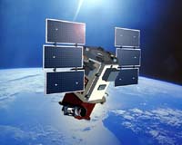
Harris Corporation has announced that its OS/COMET-based Satellite Control Center is being used to operate DigitalGlobe's QuickBird satellite. DigitialGlobe operates a commercial satellite remote sensing system that includes QuickBird. OS/COMET is an advanced software tool set featuring commercial off-the-shelf (COTS) capabilities with superior levels of flexibility, allowing users to automate ground-system solutions at any desired level throughout the life of a satellite program. "DigitalGlobe is pleased to be controlling the QuickBird satellite with the OS/COMET-based command and control system, which is significantly more advanced and flexible than our previous control system," said Jeff Culwell, director of Satellite Control Systems for DigitalGlobe. "Harris Technical Services Corporation (HTSC) met our schedule needs, delivering a LINUX-based system capable of the high level of support necessary to go operational." The QuickBird satellite, based on the Ball BCP-2000 satellite, provides commercial remote imaging with resolutions as high as .6 meters. The satellite was initially launched in 2001. "Our ability to deliver and go operational with the new LINUX version of the OS/COMET Product Suite in only 11 months illustrates HTSC's commitment to meet our customer's schedule, which is one of the cornerstones of being a true mission partner," said Bob Turner, OS/COMET program manager for HTSC. "DigitalGlobe and HTSC have developed a strong relationship that will only continue to grow with future system and support deliveries." Designed for government and commercial applications, OS/COMET is used to support both single-satellite missions and the largest and most complex satellite networks deployed today, including Iridium, GPS and fleets of spacecraft such as the 16 satellites operated by the U.S. Navy Space Operations Command (NAVSOC). OS/COMET also features a suite of "bolt-on" products that provide enhanced capabilities such as operations automation, ground equipment control, automated fault resolution, archiving/retrieval and spacecraft simulation. Related Links Harris Corporation TerraDaily Search TerraDaily Subscribe To TerraDaily Express 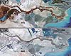 Geneva (AFP) Jun 03, 2005
An atlas of satellite photographs published by the UN environmental agency on Friday has exposed the physical damage wrought by the growing human population, including deforestation, retreating icecaps, dried seas, sprawling cities and pollution. |
|
| The content herein, unless otherwise known to be public domain, are Copyright 1995-2016 - Space Media Network. All websites are published in Australia and are solely subject to Australian law and governed by Fair Use principals for news reporting and research purposes. AFP, UPI and IANS news wire stories are copyright Agence France-Presse, United Press International and Indo-Asia News Service. ESA news reports are copyright European Space Agency. All NASA sourced material is public domain. Additional copyrights may apply in whole or part to other bona fide parties. Advertising does not imply endorsement, agreement or approval of any opinions, statements or information provided by Space Media Network on any Web page published or hosted by Space Media Network. Privacy Statement All images and articles appearing on Space Media Network have been edited or digitally altered in some way. Any requests to remove copyright material will be acted upon in a timely and appropriate manner. Any attempt to extort money from Space Media Network will be ignored and reported to Australian Law Enforcement Agencies as a potential case of financial fraud involving the use of a telephonic carriage device or postal service. |