| . |  |
. |
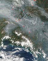
The Geographic Information Network of Alaska (GINA) at the University of Alaska Fairbanks Geophysical Institute is collaborating with other agencies to provide near-real-time satellite data to the Bureau of Land Management's Alaska Fire Service. Armed with images taken from space, fire personnel will be able to track hot spots and fire movement, even under heavy smoke that may ground mapping aircraft. Data from Landsat 5 and MODIS satellites will be available to fire crews and other users in less than 24 hours through the GINA network. Landsat 5 satellite data is now captured at the NOAA/NESDIS Fairbanks Command & Data Acquisition Station at Gilmore Creek, Alaska. GINA then transmits the data over high-speed networks to Sioux Falls, South Dakota, where it will be processed and archived at the USGS National Center for Earth Resources Observation Systems. This is the fourth season MODIS satellite data will provide information to fire personnel through GINA. The entire state of Alaska can be viewed in one pass by MODIS satellites, which makes several passes each day. Due to the satellites' multiple spectral bands, GINA is able to supply users with natural color images of smoke and terrain, as well as thermal images. MODIS images and fire detection points are processed by GINA and delivered to agencies within 40 minutes of reception. While MODIS data allows users to view the entire Alaskan landscape, Landsat 5 provides users the ability to see critical areas at a higher resolution. "This timely data will be a useful supplement for wildfire managers. The 30-meter resolution imagery from Landsat 5 will give firefighters more precise locations and finer-grained pictures than the statewide coverage of 250-meter resolution MODIS scenes we provide them several times each day," said GINA Director and University of Alaska President's Professor of Remote Sensing Buck Sharpton. Related Links GINA University of Alaska Fairbanks TerraDaily Search TerraDaily Subscribe To TerraDaily Express  Arlington VA (SPX) Jun 14, 2005
The Alliance for Earth Observations is one of more than 1,900 exhibitors participating in this week's 46th International Paris Air Show at Le Bourget Airport. |
|
| The content herein, unless otherwise known to be public domain, are Copyright 1995-2016 - Space Media Network. All websites are published in Australia and are solely subject to Australian law and governed by Fair Use principals for news reporting and research purposes. AFP, UPI and IANS news wire stories are copyright Agence France-Presse, United Press International and Indo-Asia News Service. ESA news reports are copyright European Space Agency. All NASA sourced material is public domain. Additional copyrights may apply in whole or part to other bona fide parties. Advertising does not imply endorsement, agreement or approval of any opinions, statements or information provided by Space Media Network on any Web page published or hosted by Space Media Network. Privacy Statement All images and articles appearing on Space Media Network have been edited or digitally altered in some way. Any requests to remove copyright material will be acted upon in a timely and appropriate manner. Any attempt to extort money from Space Media Network will be ignored and reported to Australian Law Enforcement Agencies as a potential case of financial fraud involving the use of a telephonic carriage device or postal service. |