| . |  |
. |
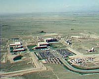
50th Space Wing Public Affairs Schriever AFB CO (SPX) Mar 26, 2009 The 2nd and 19th Space Operations Squadrons here assumed control of the Air Force's newest GPS satellite shortly after its launch from Cape Canaveral Air Force Station, Fla., March 24. The satellite, named GPS IIR-20(M), is the 34th satellite in the GPS constellation, which provides precise navigation and timing data to military and civilian customers around the world. The GPS team, which includes 2nd and 19th SOPS, the GPS Wing at the Space and Missile Systems Center at Los Angeles Air Force Base, Calif., and the 45th Space Wing at Patrick AFB, Fla., all played a role in the successful launch, said Lt. Col. Deanna Burt, 2nd SOPS commander. "Operations have gone smoothly, and we're on target to have the satellite operational for users by April 5," Colonel Burt said. Space operators with 2nd SOPS and 19th SOPS took over early-orbit operations for the new satellite 68 minutes after launch, said Lt. Col. Douglas Schiess, 2nd SOPS operations officer. "We're getting it ready to provide its combat effects to warfighters as soon as possible," Colonel Schiess said. GPS IIR-M satellites provide combat capability for military applications such as Joint Direct Attack Munitions and handheld, vehicle-based and aircraft navigation aids. Civilian applications include ATMs, bank and stock market transactions and power grid management. Currently, 31 of the 34 GPS satellites in orbit transmit navigation and timing signals to users. A Delta II launch vehicle carried GPS IIR-20(M) into low-Earth orbit. From there, a booster will lift the satellite into its operational orbit approximately 12,500 miles above the Earth. The launch was delayed from June 2008 due to a fault in the 40-second timer that triggers separation of the third-stage booster from the satellite. Air Force and contractor engineers resolved the problems, said Lt. Col. John Wagner, mission director for the Launch and Range Systems Wing at Los Angeles Air Force Base, Calif. The IIR-M spacecraft includes several upgrades from the earlier Block IIR model. A modernized antenna panel provides a stronger signal that is more resistant to GPS jamming and stronger encryption for military signals. It also includes two military signals and one civil signal beyond those transmitted by earlier GPS satellites. Both 2nd SOPS and 19th SOPS are responsible for command and control of GPS satellites throughout most of their life cycles, including early orbit, anomaly and disposal operations. The 19th SOPS is an Air Force Reserve associate unit for 2nd SOPS. Other Air Force Space Command agencies that supported the launch include the 22nd Space Operations Squadron here, the 45th Space Wing at Patrick AFB, Fla., and the Space and Missile Systems Center at Los Angeles AFB. Contractor partners included United Launch Alliance, the Aerospace Corporation and Lockheed Martin Corporation. Share This Article With Planet Earth
Related Links Schriever AFB GPS GPS Applications, Technology and Suppliers
 San Jose CA (SPX) Mar 25, 2009
InSync Software has announced it has signed an original equipment manufacturer (OEM) agreement with IBM that will allow the company to integrate IBM open technology into its own Radio Frequency Identification (RFID) and sensor-driven food safety and asset management products. |
|
| The content herein, unless otherwise known to be public domain, are Copyright 1995-2007 - SpaceDaily.AFP and UPI Wire Stories are copyright Agence France-Presse and United Press International. ESA Portal Reports are copyright European Space Agency. All NASA sourced material is public domain. Additional copyrights may apply in whole or part to other bona fide parties. Advertising does not imply endorsement,agreement or approval of any opinions, statements or information provided by SpaceDaily on any Web page published or hosted by SpaceDaily. Privacy Statement |
 del.icio.us
 Digg
Digg Reddit
 YahooMyWeb
 Google