| . |  |
. |
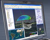
Exton PA (SPX) Aug 10, 2004 AGI and Overlook Systems Technologies Monday released Navigation Tool Kit, a comprehensive software analysis tool for the satellite navigation (SATNAV) community. Navigation Tool Kit predicts the performance of navigation equipment by analyzing and modeling obstacles that cause inaccuracies within the system. These factors include variations in hardware, atmospheric distortions, radio frequency interference, and satellite orbital errors. GPS correction files provided for Navigation Tool Kit by new AGI business partner NavCom Technology further adjust for inaccuracies, making Navigation Tool Kit the most precise navigation software solution available to the SATNAV community. Designed with an easy-to-use interface, Navigation Tool Kit is tailored for both SATNAV analysis experts and end-users. "Having a precise navigation solution is critical to SATNAV missions," said Francesco Linsalata, AGI's chief operating officer. "Navigation Tool Kit predicts GPS accuracy with a level of fidelity that will greatly benefit the millions of civil and military users who rely on this growing technology for their mission's success." Related Links Overlook Systems Analytical Graphics SpaceDaily Search SpaceDaily Subscribe To SpaceDaily Express  Houston TX (SPX) Aug 09, 2004
In a rescue situation such as a fire or a chemical spill, every second is crucial for both the rescuer and those who need help. |
|
| The content herein, unless otherwise known to be public domain, are Copyright 1995-2006 - SpaceDaily.AFP and UPI Wire Stories are copyright Agence France-Presse and United Press International. ESA PortalReports are copyright European Space Agency. All NASA sourced material is public domain. Additionalcopyrights may apply in whole or part to other bona fide parties. Advertising does not imply endorsement,agreement or approval of any opinions, statements or information provided by SpaceDaily on any Web page published or hosted by SpaceDaily. Privacy Statement |