| . |  |
. |
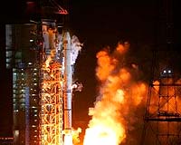
Xichang, China (XNA) Apr 16, 2007 China on early Saturday morning launched a navigation satellite, part of the country's "Compass" navigational system, which is expected to provide services to customers all over China and neighboring countries by 2008. The carrier rocket, Long March 3-A, blasted off from the Xichang Satellite Launch Center in southwest China's Sichuan Province at 4:11 a.m., and sources with the center said that the satellite had "accurately" entered its orbit, at the height of 21,500 km. The "Compass" navigational system is mainly designed for the country's economic development, providing navigation and positioning services in transportation, meteorology, petroleum prospecting, forest fire monitoring, disaster forecast, telecommunications and public security, among others. With more satellites to be sent into orbits in the coming years, the system will cover China and its neighboring countries by 2008,before being expanded into a global network of navigation and positioning. On February 3, China successfully put a test "Compass" satellite into the orbit, the fourth of such experimental satellites launched since 2000. Experts said the "Compass" navigation experimental system is operating well and has played a significant role in providing all-weather and all-day navigation and positioning information. China is one of the few countries that are capable of developing navigation satellite system on its own. Previous reports said it will provide clients with positioning accuracy within 10 meters, velocity accuracy with 0.2 meter per second and timing accuracy within 50 nanoseconds. The system can help clients know their location at any time and place with accurate longitude, latitude and altitude data, and will offer "safer" positioning, velocity, timing communications for authorized users. The system includes at least 35 satellites, five geostationary Earth orbit (GEO) and 30 medium Earth orbit (MEO) satellites, according to previous reports. China is willing to cooperate with other countries in developing its satellite navigation industry to allow the "Compass" system to operate with other global satellite positioning systems such as the United States' GPS, Russia's GLONASS and Europe's GALILEO navigational system, sources said. The satellite and carrier rocket were developed respectively by the China Academy of Space Technology and China Academy of Launch Vehicle Technology, which are under the China Aerospace Science and Technology Corporation. The launch represents the 97th flight of China's Long March series of rockets. China's first manned spacecraft, Shenzhou V, blasted off in October 2003, making China the third nation after the Soviet Union and the United States to send a human into space, and another manned spaceship Shenzhou VI carrying two astronauts circled around the Earth continuously for five days before a safe return in October, 2005. China's next manned space flight Shenzhou VII, the third in its space program, is scheduled to take place in 2008.
Source: Xinhua News Agency Email This Article
Related Links  Reston VA (SPX) Apr 16, 2007
Northrop Grumman has submitted a proposal to compete for the U.S. Air Force's Global Positioning System (GPS) Next Generation Control Segment (OCX) contract. |
|
| The content herein, unless otherwise known to be public domain, are Copyright 1995-2006 - SpaceDaily.AFP and UPI Wire Stories are copyright Agence France-Presse and United Press International. ESA PortalReports are copyright European Space Agency. All NASA sourced material is public domain. Additionalcopyrights may apply in whole or part to other bona fide parties. Advertising does not imply endorsement,agreement or approval of any opinions, statements or information provided by SpaceDaily on any Web page published or hosted by SpaceDaily. Privacy Statement |