| . |  |
. |
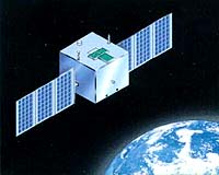
Beijing - July 20, 2001 China is in final testing and preparation to launch a new satellite dedicated to study ocean colours and phenomena. The launch may come as early as this month. The Haiyang-1 (HY-1, Haiyang means "ocean") remote sensing satellite is the first in a new series of satellites that will make observations of ocean colours and conditions, with an emphasis on areas near China. The State Oceanic Administration (SOA) first disclosed the construction of the satellite in August last year. SOA suggested back then that a new HY satellite would be launched every two years in the next decade. Earlier this year during the extensive discussion and formulation of the current tenth five-year economic development plan, abbreviated the "10 5 Plan", the government confirmed its commitment to develop the HY satellite series. The May 2001 issue of the Chinese-language monthly publication Aerospace China reports that although there is no clear indication of how many satellites in the series would be launched in the next five years, the "10 5 Plan" states that key technological breakthroughs would be required to equip the second satellite HY-2 to monitor the dynamical environment of oceans. This includes obtaining data on surface wind field, surface and wave heights, current flows and temperatures. Under the original timeline HY-1 was targeted to launch in May 2001. In mid-January SOA announced that the launch would be delayed for two months until July. Data from HY-1 will help develop a focused exploration and reasonable exploitation of biological, fishery, and geological resources in coastal waters of China and in the oceans. In addition HY-1 will monitor pollution and mitigate disasters in oceans, and perform oceanographic studies in general. For example HY-1 observations will be useful in obtaining ocean colours and temperatures, chlorophyll concentration, suspended silt content, and sea ice conditions. Scientists will also use HY-1 data to study submarine topography in shallow water, fish and algae distribution, red tides in coastal areas, tropical cyclones, and phenomena related to El Nino such as the switching of the ocean current flow along the east coast of Asia. Such a swing between the warm Kuroshio current flow, which brings warm water from the Equator poleward, and the cold Oyashio current flow, which delivers cold water in reverse from the pole southward, can devastate the Korean and Japanese fishing industries. Reversal of this current flow also changes the weather pattern that can greatly affect rice production in China and its neighbours where growing population places an increasing demand on rice supply. Meanwhile China Ocean News reported that construction of supporting facilities, including two ground reception stations, began in October last year. The two receiving stations are located here in Beijing and in Sanya, which is the largest city on the south coast of the Hainan Island in the South China Sea. At the groundbreaking ceremony of the Sanya Station, Deputy Director of the New High Technology Department of SOA Kang Jian explained why the city was chosen as the site of a reception station: "The Sanya Station is mainly responsible for receiving remote sensing data from HY-1 on southern ocean areas and distributing it to the National Satellite Oceanic Application Center in Beijing. "At the same time the Station provides information to the local government for developing oceanic industries and their integrated management, and supports a sustainable economic development related to the ocean in the Hainan Province and Sanya." Kang added that the Sanya site selection would also open a window of opportunities for international exchange in oceanographic space technologies. Work on the associated computing network also started. Through an open and competitive tender system, SOA awarded a $12 million renminbi (US $1.45 million) network integration and maintenance contract to North Eagle Technology, a company which has extensive experience in large-scale computer network integration. New Bird A Microsat The Chinese Academy of Space Technology (CAST) is the builder of HY-1. The spacecraft employs a CAST968B bus, one of the three common platforms that CAST develops. The three-axis stabilized CAST968B bus is evolved from the Shijian-5 (SJ-5, Shijian means "practice") microsat bus, a science mission that was launched on May 10, 1999 along with the Fengyun-1C metsat (FY-1C, Fengyun means "wind and cloud"). The experimental HY-1 measures 1.2m x 1.1m x 1.1m and weighs 360kg. The final orbit of the spacecraft will be sunsynchronous at an altitude of 798km and an inclination of 98.8 degrees. According to CAST, at the planned orbit groundtrack repeat is every 3 days for the 10-channel multispectral ocean colour and temperature scanner (OCTS) and every 7 days for the 4-colour charged coupled device (CCD) imager. Changchun Institute of Optics, Fine Mechanics and Physics (CIOMP), an institution of the Chinese Academy of Sciences (CAS), develops and builds the wide-field CCD imager which has a ground resolution of 250m. The spacecraft will transmit data in the X-band. Realtime data downlink is limited to observations of northwestern Pacific areas, including Bo Hai, Huang Hai (Yellow Sea), Nan Hai (South China Sea) and Sea of Japan. The prime observing areas will be coastal zones and continental shelves of China. Observations of other areas will be transmitted on a delayed basis. CAST includes a GPS positioning system and small propulsion systems on HY-1 to increase its capability in orbit adjustment and maintenance. These subsystems will help the spacecarft achieve a pointing accuracy of 0.5 deg or less, and detect attitude drift of 0.3 deg or less. The design life expectancy of HY-1 is 2 years. The primary instrument, OCTS, had its first field test and calibration from Oct. 15 to Nov. 3 last year. The Oceanic Technology Research Institute of SOA in Tianjin, in the eastern Hebei Province, coordinated field observations at Huang Hai (Yellow Sea) to test and carry out a simulated radiometric calibration of the infrared sensing portion of the instrument. The test team took measurements at 41 locations of optical characteristics of the sea, optical properties and meteorology of the atmosphere above the observing areas, and other physical parameters. The team gained valuable experience in calibrating the instrument, obtaining realtime data, and checking the authenticity of data products. Towards An Independent Oceanographic Info System The Hi-Tech Research and Development Program of China, also known as the "863 Program", recognizes the importance of remotely sensed information in the overall scheme of a Chinese oceanic information system. The Program outlines four layers of requirements for the information system:
With the imminent launch of HY-1, China will enter a new era of satellite oceanography and make the first step towards the goal of establishing its own independent oceanic information system. Related Links SpaceDaily Search SpaceDaily Subscribe To SpaceDaily Express  Beijing - July 20, 2001
The birth of the HY-1 satellite is more than a decade of planning and development, according to a report in the May 1997 issue of Aerospace China. |
|
|
|
|
|
|
|
|
|
|
|
|
|
| The content herein, unless otherwise known to be public domain, are Copyright 1995-2006 - SpaceDaily.AFP and UPI Wire Stories are copyright Agence France-Presse and United Press International. ESA PortalReports are copyright European Space Agency. All NASA sourced material is public domain. Additionalcopyrights may apply in whole or part to other bona fide parties. Advertising does not imply endorsement,agreement or approval of any opinions, statements or information provided by SpaceDaily on any Web page published or hosted by SpaceDaily. Privacy Statement |