| . |  |
. |
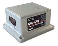
Middletown RI (SPX) May 12, 2008 KVH Industries has introduced the CNS-5000, a self-contained navigation system that combines fiber optic gyro (FOG)-based inertial measurement technology from KVH with global positioning system (GPS) technology from NovAtel. This rugged navigation solution affordably provides the precise position and orientation of a host platform on a continuous basis, even during periods where GPS signals are blocked by natural or man-made obstructions or conditions. The CNS-5000 is designed specifically for demanding commercial applications, such as dynamic surveying, precision agriculture, container terminal management, and autonomous vehicle navigation, where the ability to determine the precise position and orientation of a piece of equipment or a mobile platform is critical. "The new CNS-5000 is a remarkable GPS/IMU solution that is well-suited for a wide array of commercial applications worldwide," explains Dan Conway, KVH's vice president of business development. "The combination of NovAtel's GPS technology with our precision fiber optic gyros and inertial technologies led to an entirely new single-enclosure approach to GPS/IMU systems, saving customers space and weight in their installations without compromising accuracy or performance." Through its seamless integration of KVH's FOG-based IMU with NovAtel's OEMV GPS precision receiver technology, the CNS-5000 provides a groundbreaking low-cost, small form factor solution for 3-D positioning, velocity, and attitude measurement. The deep coupling of the GPS and IMU technologies within the CNS-5000 optimizes the raw GPS and IMU data, delivering a superior position, velocity and attitude solution. Composed entirely of commercial components and rugged enough to operate in extremely demanding conditions, the CNS-5000 is also designed to meet COTS requirements. This minimizes the operational complexities for customers whose products cross international boundaries. "NovAtel is excited to be working closely with an innovative partner like KVH Industries to bring state-of-the-art products like this to market. This product extends our portfolio into markets that have been difficult to penetrate with standard two-box GPS/INS solutions, due to high price or complex export controls," said Graham Purves, vice president, sales and marketing for NovAtel, Inc. Community Email This Article Comment On This Article Share This Article With Planet Earth
Related Links CNS-5000 NovAtel GPS Applications, Technology and Suppliers
 Paignton, England (SPX) May 06, 2008
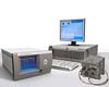
Spirent Communications has announced improved high dynamic capabilities on its new Spirent GSS8000 simulation system. The Spirent GSS8000 is designed for use in the most demanding applications, and is capable of simulating ultra-high dynamics with industry leading accuracy. The Spirent GSS8000 supports up to 20,000g signal dynamics, up to 120,000 m/s velocity and 50Hz (4ms) processing rates. |
|
| The content herein, unless otherwise known to be public domain, are Copyright 1995-2007 - SpaceDaily.AFP and UPI Wire Stories are copyright Agence France-Presse and United Press International. ESA Portal Reports are copyright European Space Agency. All NASA sourced material is public domain. Additional copyrights may apply in whole or part to other bona fide parties. Advertising does not imply endorsement,agreement or approval of any opinions, statements or information provided by SpaceDaily on any Web page published or hosted by SpaceDaily. Privacy Statement |
 del.icio.us
 Digg
Digg Reddit
 YahooMyWeb
 Google