| . |  |
. |
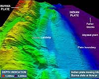
San Francisco CA (SPX) Dec 07, 2005 The first research expedition to directly observe the seafloor near the epicenter of the earthquake that caused the December 2004 Indian Ocean tsunami has revealed unexpected results that will dramatically improve forecasting of future tsunamis. Scientific results of the expedition were reported at the fall meeting of the American Geophysical Union in San Francisco on Dec. 5-6. An international team of 27 scientists, led by Kate Moran of the University of Rhode Island and David Tappin of the British Geological Survey and including biologists, seismologists, geologists and tsunami modelers, spent 17 days at sea last May exploring the seafloor off the coast of Sumatra to gain a better understanding of the bottom deformation that led to the devastating tsunami. The team found significant differences between what they expected to find based on tsunami and earthquake observations and models and what they actually observed on the seafloor. "This event marks a sea change in our understanding of giant earthquakes and the generation of tsunami waves because modern instruments recorded the quake better than ever before, and tsunami observations of wave heights, arrival times and coastal impact were rapidly gathered immediately after the event," said Moran. The research team found far fewer underwater landslides and generally less widespread disturbance of the seafloor than would have been expected given the size of the earthquake. "That might mean that we�re safer than we realize, because the material in that environment might be dissipating the seismic energy more than we thought," Moran said. Using the results of a British acoustic survey of the region conducted last February that identified disturbances on the sea floor, the researchers used remotely operated vehicles and other techniques to investigate those disturbances to determine if and how they played a role in the tsunami. One major underwater landslide they examined probably occurred more than 1,000 years ago, but in an area they called The Ditch they found large vertical displacements of the seafloor that were very fresh and were almost certainly the result of the Dec. 26 earthquake. "In some places in The Ditch we found up to 12 meters of seafloor displacement, and that�s almost twice as high as seismologists predicted would have occurred," said Stephan Grilli, an ocean engineering professor from the University of Rhode Island who led the team of tsunami modelers. Based on the geologic information collected during the expedition and the observations and measurements made when the tsunami struck the coastline, Grilli refined his tsunami model to replicate the actual seafloor movements and tsunami waves generated in the Indian Ocean. The more accurate model has also been applied to forecast future tsunamis in other locations. "The more we learn about the motion of the seafloor, the more we can improve tsunami forecasting and mitigation," Grilli said. "It helps us improve tsunami warning systems by knowing where to put measurement gauges that will give us the necessary advanced warning." Grilli has applied his updated model to a fault off the Oregon coast called Cascadia, which has been moving 6 centimeters per year since the last large earthquake occurred in the area in 1700 and where seismologists have long predicted another large earthquake, possibly up to 9.2 in magnitude, could occur. The refined model now predicts that an earthquake of that size could generate tsunami wave run-ups of up to 30 meters in some locations along the Pacific Northwest coast � almost three times higher than previously predicted � and significant waves could reach as far away as Japan and Russia. "Communities in Oregon and Washington have been anticipating waves of only 10 to 12 meters or so, but now they need to be even better prepared," Grilli said. Primary funding for the research expedition was provided by the BBC and Discovery Channel. A documentary about the expedition will air on both channels on Dec. 18. Related Links University of Rhode Island American Geophysical Union SpaceDaily Search SpaceDaily Subscribe To SpaceDaily Express  Moroni (AFP) Dec 07, 2005
A volcano in the Indian Ocean's Comoro islands was still spewing lava Wednesday almost two weeks after it began erupting, a senior vulcanologist said. |
|
| The content herein, unless otherwise known to be public domain, are Copyright 1995-2006 - SpaceDaily.AFP and UPI Wire Stories are copyright Agence France-Presse and United Press International. ESA PortalReports are copyright European Space Agency. All NASA sourced material is public domain. Additionalcopyrights may apply in whole or part to other bona fide parties. Advertising does not imply endorsement,agreement or approval of any opinions, statements or information provided by SpaceDaily on any Web page published or hosted by SpaceDaily. Privacy Statement |