| . |  |
. |
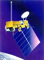
Aurora CO (SPX) Jul 08, 2004 Raytheon has achieved a significant program milestone by successfully capturing data from the WindSat Coriolis weather satellite, making the company's Command, Control, and Communications Segment's multi-mission network capability one of the first National Polar-orbiting Operational Environmental Satellite System (NPOESS) segments to go operational. The multi-mission capability incorporates a new fiber optic network from Svalbard to Tromso, on the mainland of Norway, to the continental United States. The network sends data to the Coriolis Data Distribution site in Suitland, Md., and the data are used to determine global sea surface wind speed and direction as well as to monitor solar mass ejections from the sun. The network provides the NPOESS program with high-speed data transfer, 155 Mbps connectivity, from the Svalbard, Norway, ground station previously available only through slower, more expensive satellite links, reducing costs for existing programs and providing additional capacity for future missions including the NPOESS Preparatory Project. The ground station is so far north that it can see polar-orbiting satellites on every orbit. This enables it to capture blind orbits not visible from the primary station at Fairbanks, Alaska. "For the mission to start taking operational passes within 45 days of getting the green light is exceptional," said Mike Mader, director of the NPOESS program for Raytheon. "Our team worked closely with the customer to ensure delivery in a reliable and timely manner." The next step for Raytheon's Command, Control, and Communications Segment is to integrate NASA missions at Svalbard and provide them with the same high- speed terrestrial data transfer capability used for Coriolis, then to transition operations to a new antenna in the fall.
Related Links 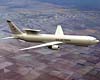 El Segundo CA (SPX) Jul 08, 2004
A Northrop Grumman Corporation- led team and the U.S. Air Force have reached a major milestone on a next-generation airborne surveillance radar program by finalizing the radar's baseline design and starting the development and demonstration phase of the program. |
|
| The content herein, unless otherwise known to be public domain, are Copyright 1995-2006 - SpaceDaily.AFP and UPI Wire Stories are copyright Agence France-Presse and United Press International. ESA PortalReports are copyright European Space Agency. All NASA sourced material is public domain. Additionalcopyrights may apply in whole or part to other bona fide parties. Advertising does not imply endorsement,agreement or approval of any opinions, statements or information provided by SpaceDaily on any Web page published or hosted by SpaceDaily. Privacy Statement |