| . |  |
. |
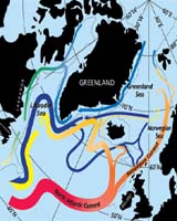
Greenbelt - Apr 16, 2004 A North Atlantic Ocean circulation system weakened considerably in the late 1990s, compared to the 1970s and 1980s, according to a NASA study. Sirpa Hakkinen, lead author and researcher at NASA's Goddard Space Flight Center, Greenbelt, Md. And co-author Peter Rhines, an oceanographer at the University of Washington, Seattle, believe slowing of this ocean current is an indication of dramatic changes in the North Atlantic Ocean climate. The study's results about the system that moves water in a counterclockwise pattern from Ireland to Labrador were published on the Internet by the journal Science on the Science Express website. The current, known as the sub polar gyre, has weakened in the past in connection with certain phases of a large-scale atmospheric pressure system known as the North Atlantic Oscillation (NAO). But the NAO has switched phases twice in the 1990s, while the subpolar gyre current has continued to weaken. Whether the trend is part of a natural cycle or the result of other factors related to global warming is unknown. "It is a signal of large climate variability in the high latitudes," Hakkinen said. "If this trend continues, it could indicate reorganization of the ocean climate system, perhaps with changes in the whole climate system, but we need another good five to 10 years to say something like that is happening." Rhines said, "The subpolar zone of the Earth is a key site for studying the climate. It's like Grand Central Station there, as many of the major ocean water masses pass through from the Arctic and from warmer latitudes. They are modified in this basin. Computer models have shown the slowing and speeding up of the subpolar gyre can influence the entire ocean circulation system." Satellite data makes it possible to view the gyre over the entire North Atlantic basin. Measurements from deep in the ocean, using buoys, ships and new autonomous "robot" Seagliders, are important for validating and extending the satellite data. Sea-surface height satellite data came from NASA's Seasat (July, August 1978), U.S. Navy's Geosat (1985 to 1988), and the European Space Agency's European Remote Sensing Satellite1/2 and NASA's TOPEX/Poseidon (1992 to present). Hakkinen and Rhines were able to reference earlier data to TOPEX/Poseidon data, and translate the satellite sea-surface height data to velocities of the subpolar gyre. The subpolar gyre can take 20 years to complete its route. Warm water runs northward through the Gulf Stream, past Ireland, before it turns westward near Iceland and the tip of Greenland. The current loses heat to the atmosphere as it moves north. Westerly winds pick up that lost heat, creating warmer, milder European winters. After frigid Labrador Sea winters, the water in the current becomes cold, salty and dense, plunges beneath the surface, and heads slowly southward back to the equator. The cycle is sensitive to the paths of winter storms and to the buoyant fresh water from glacial melting and precipitation, all of which are experiencing great change. While previous studies have proposed winds resulting from the NAO have influenced the subpolar gyre's currents, this study found heat exchanges from the ocean to the atmosphere may be playing a bigger role in the weakening current. Using Topex/Poseidon sea-surface height data, the researchers inferred Labrador Sea water in the core of the gyre warmed during the 1990s. This warming reduces the contrast with water from warmer southern latitudes, which is part of the driving force for ocean circulation. The joint NASA-CNES (French Space Agency) Topex/Poseidon oceanography satellite provides high-precision data on the height of the world's ocean surfaces, a key measure of ocean circulation and heat storage in the ocean. NASA's Earth Science Enterprise is dedicated to understanding the Earth as an integrated system and applying Earth System Science to improve prediction of climate, weather and natural hazards using the unique vantage point of space. NASA, the National Oceanic and Atmospheric Administration, and the National Science Foundation funded the study. Related Links SpaceDaily Search SpaceDaily Subscribe To SpaceDaily Express  London - Apr 08, 2004
By mid century cities and towns along the American west coast could be suffering serious water shortages in response to climate change. As Arctic sea-ice melts, annual rainfall is forecast to drop by as much as 30 per cent from Seattle to Los Angeles, and inland as far as the Rocky Mountains reports New Scientist. |
|
| The content herein, unless otherwise known to be public domain, are Copyright 1995-2006 - SpaceDaily.AFP and UPI Wire Stories are copyright Agence France-Presse and United Press International. ESA PortalReports are copyright European Space Agency. All NASA sourced material is public domain. Additionalcopyrights may apply in whole or part to other bona fide parties. Advertising does not imply endorsement,agreement or approval of any opinions, statements or information provided by SpaceDaily on any Web page published or hosted by SpaceDaily. Privacy Statement |