| . |  |
. |
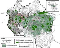
Woods Hole MA (SPX) Jun 11, 2007 Though the dense humid forests of Central Africa have been regarded as among the most pristine on Earth, the expansion of industrial logging and the accompanying proliferation of road density are threatening the future of this important ecosystem. Woods Hole Research Center scientists are using satellite imagery taken from 1976 to 2003 to study the development of industrial logging and road density in Central Africa so that scientists, conservation agencies and other organizations can better understand the trends and implications of such expansion. The work is profiled in the current issue of Science. According to Nadine Laporte, an associate scientist at the Woods Hole Research Center and lead author of the work, "It has never been timelier to monitor forest degradation in Central Africa because there is still an opportunity to make a significant difference in reducing the amount of deforestation. The Democratic Republic of Congo contains most of the remaining forest and is the last frontier for logging expansion in Africa." Researchers mapped nearly 52,000 km of logging roads within the forested region, which includes Cameroon, Central African Republic, Equatorial Guinea, Gabon, Republic of Congo, and Democratic Republic of Congo. Prior to this work, there were few reliable data sets available to monitor both legal and illegal logging. This study provides the first synoptic view of industrial logging in Central Africa, enabling conservation agencies, government agencies, scientists, industry officials, and others to better gauge how the expansion of logging is impacting the forest and its inhabitants, and how better planning might mitigate damage. Jared Stabach, a research assistant at the Center and second author, comments, "Roads provide access, and this research provides clear evidence that the rainforests of Central Africa are not as remote as they once were....a bad thing for many of the species that call it home." Monitoring the expansion of logging in last dense humid forest of Central Africa is not only important for biodiversity conservation but also for climatic change. Industrial logging in Central Africa is the most extensive land use with more than 30 percent of the forest under logging concession and the clearing of these forests could significantly increase carbon emissions. Co-author Scott Goetz, a senior scientist at the Center, notes that the combination of increasing population, economic development and climatic change means that "Africa is poised for irreversible change, so it is important to help African countries with tools to monitor what is happening to their forests." Dr. Laporte adds, "This work helps to provide key data to local scientists, allowing them the tools needed to work with policy makers to help manage their forests, and in the process reduce biodiversity loss and carbon emissions from deforestation." Dr. Laporte is a biologist whose research centers on the applications of satellite imagery to tropical forest ecosystems, including vegetation mapping, land-use change, and deforestation causes and consequences. She has been involved in numerous environmental projects in Africa over the past 20 years, working with in-country scientists, foresters, and international conservation organizations to develop integrated forest monitoring systems and promote forest conservation. She received her doctorate in tropical biogeography from l'Universite Paul Sabatier in Toulouse, France. Mr. Stabach works in the Geographic Information Systems (GIS) and Remote Sensing Laboratory on the Center's Africa program, monitoring changes and threats to the rainforests and threatened species throughout the Central Africa region. His master's research focused on the use of remote sensing technologies to identify Matschie's tree kangaroo habitat in Papua New Guinea. He received his B.S. from Providence College and his M.S. from the University of Rhode Island. Dr. Goetz works on the application of satellite imagery to analyses of environmental change, including monitoring and modeling links between land use change, forest productivity, biodiversity, climate, and human health. Before joining the Center, he was on the faculty at the University of Maryland for seven years, where he maintains an adjunct associate professor appointment, and was a research scientist at NASA's Goddard Space Flight Center. He received his Ph.D. from the University of Maryland. Email This Article
Related Links 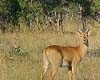 Harare (AFP) June 06, 2007
Israel Thebe points in despair to dozens of fresh stumps that have appeared overnight in the heart of Mukuvisi Woodlands, on the outskirts of Harare. "It takes a good 50 years for a tree to grow fully," said the forestry manager. "This took place in just one night." Mukuvisi has long been a popular destination for day trips by schoolchildren from the Zimbabwean capital who are able to catch a glimpse of wildlife such as giraffe, zebra and several antelope species on their doorstep. |
|
| The content herein, unless otherwise known to be public domain, are Copyright 1995-2006 - SpaceDaily.AFP and UPI Wire Stories are copyright Agence France-Presse and United Press International. ESA PortalReports are copyright European Space Agency. All NASA sourced material is public domain. Additionalcopyrights may apply in whole or part to other bona fide parties. Advertising does not imply endorsement,agreement or approval of any opinions, statements or information provided by SpaceDaily on any Web page published or hosted by SpaceDaily. Privacy Statement |