| . |  |
. |
Manila (AFP) April 8, 2011 President Benigno Aquino said Friday he plans to have a 3-D map of the Philippine archipelago created as part of an effort to guard against disasters. The project, which will cost a billion pesos ($23.2 million), will help pinpoint communities which are vulnerable to floods, landslides and other natural disasters, the president said. "This mapping will help us check every corner of our country so we will have more information on which areas are vulnerable to floods," Aquino said at the opening of a government flood-control project. "This will be a big help in giving us enough time to help our countrymen who are about to be hit by a flood," he added. He said the project was justified despite its high price because the Philippines was identified as "geo-hazard area" where catastrophes were common. Aquino did not say how the 3-D mapping would be carried out or when it would be completed. The Philippines is considered one of the world's most vulnerable countries to natural disasters. It sits on the Pacific's earthquake and volcano belt, and is battered by an average of 20 typhoons a year which often bring devastating floods.
earlier related report The second stage of a five-step alert system has been imposed around Taal Volcano, a visitor spot located 65 kilometres (40 miles) south of Manila, after increased signs of activity were detected. While this does not mean an eruption is imminent, government volcano monitoring officer Julio Sabit said tourists and residents were warned to steer clear of Taal's crater and from thermal vents on its northern side. "It is still a grey area. We still cannot say if it will culminate in an eruption," Sabit told AFP. The volcano could suffer intensified activity but could also slowly subside as it did last year, after showing increasing activity in June, Sabit said. Taal is one of the most unstable of the country's 22 known active volcanoes with 33 recorded eruptions, the last one in 1977. A lake surrounding the crater prevented deaths in 1977 and during other eruptions, as the body of water protected outlying areas from the lava.
Share This Article With Planet Earth
Related Links Earth Observation News - Suppiliers, Technology and Application
 Arctic Ice Gets A Check Up
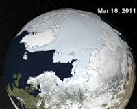
Grreenbelt MD (SPX) Apr 01, 2011 Scientists tracking the annual maximum extent of Arctic sea ice said that 2011 was among the lowest ice extents measured since satellites began collecting the data in 1979. Using satellites to track Arctic ice and comparing it with data from previous years is one way that scientists track change in the Arctic system. "For the first 20 years of the satellite record, the average annual maxim ... read more |
|
| The content herein, unless otherwise known to be public domain, are Copyright 1995-2010 - SpaceDaily. AFP and UPI Wire Stories are copyright Agence France-Presse and United Press International. ESA Portal Reports are copyright European Space Agency. All NASA sourced material is public domain. Additional copyrights may apply in whole or part to other bona fide parties. Advertising does not imply endorsement,agreement or approval of any opinions, statements or information provided by SpaceDaily on any Web page published or hosted by SpaceDaily. Privacy Statement |

 del.icio.us
 Digg
Digg Reddit
 YahooMyWeb
 Google