| . |  |
. |
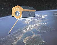
Boulder CO (SPX) May 21, 2007 GeoOptics is an international consortium formed to deploy and operate CICERO, which will consist of 100 micro-satellites in Low-Earth Orbit (LEO) performing Global Positioning System and Galileo atmospheric radio occultation (GNSS-RO). CICERO will deliver critical data on the state of the Earth's atmosphere and ionosphere in near real time to forecasters and researchers worldwide at an accuracy and vertical resolution 20 to 50 times greater than is possible with the current operational space based systems. GNSS-RO delivers profiles of atmospheric density, pressure, temperature, moisture, and geopotential heights, along with global ionospheric electron distribution and a host of derived products. Principal applications are global weather forecasting, hurricane and storm track prediction, climate change research, and space weather (geomagnetic storm) monitoring. Recent experiments at the National Center for Atmospheric Research in Boulder, CO, show that GNSSRO offers breakthrough improvements in forecasting of hurricanes and will allow for the first time the direct observation of subtle long-term temperature changes above the Earth's surface. CICERO expands on the powerful GPS-RO sensing technique pioneered in the US over the past 15 years by NASA, the National Science Foundation, and the National Oceanic and Atmospheric Administration, and by a variety of countries around the world. Demonstration sensors are currently flying on several international space missions, including CHAMP, SAC-C, GRACE, COSMIC and soon with TerraSAR-X. In addition to GNSS-RO, several other small remote sensing payloads are under evaluation. CICERO instruments and spacecraft have been under development since early 2006. GeoOptics has teamed with Broad Reach Engineering to develop the GNSS-RO sensors, the host micro-spacecraft, and other space segment infrastructure. Broad Reach built the occultation instruments (called IGOR) for COSMIC, TACSAT-2 and TerraSAR-X, and for several upcoming missions, including EQUARS, Tandem-X, and KOMPSAT-5. Broad Reach has in development an advanced Galileo-ready GNSS-RO sensor called Pyxis-RO. Pyxis-RO is the CICERO mission's primary instrument. CICERO is on track for an initial launch of 10 spacecraft in October of 2010, with follow-on launches soon after to reach a sustained array of 100 spacecraft. The full constellation will deliver nearly 100,000 atmospheric profiles each day. Email This Article
Related Links  Washington (UPI) May 18, 2007
Efforts to prepare for public health disasters are leaving out a critical component, experts say: the individual citizen. "Citizens have to get involved," said Maurice Ramirez, co-founder of Disaster Life Support of North America, a company that educates officials and the public about disaster preparedness and recovery. |
|
| The content herein, unless otherwise known to be public domain, are Copyright 1995-2006 - SpaceDaily.AFP and UPI Wire Stories are copyright Agence France-Presse and United Press International. ESA PortalReports are copyright European Space Agency. All NASA sourced material is public domain. Additionalcopyrights may apply in whole or part to other bona fide parties. Advertising does not imply endorsement,agreement or approval of any opinions, statements or information provided by SpaceDaily on any Web page published or hosted by SpaceDaily. Privacy Statement |