| . |  |
. |
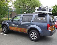
London, UK (SPX) May 22, 2008 Infoterra has launched Rapid Surveyor, a new mobile laser mapping system. Infoterra has invested in the next-generation of laser technology, specifically designed for mobile use, to enable the capture of precise information of the built/natural environment at unrivalled resolution and coverage. For example, Rapid Surveyor can identify and accurately position assets, such as poles and road drainage features, for planning and infrastructure management. Rapid Surveyor captures an unprecedented level of high quality data with a speed of capture far faster than traditional terrestrial-based surveys. Due to each survey taking less time, but delivering an extremely accurate and dense dataset, the Rapid Surveyor solution is highly cost-effective for a wide range of applications. Rapid Surveyor makes up to 200,000 measurements per second, allowing highly detailed 3D information to be captured from a moving vehicle. Its unique multi-directional design provides a complete 360 degree field-of-view to maximise data coverage within a 100m radius. This capacity enables new levels of detail and precision to produce realistic street-level visualisations. In addition, up to 600 colour images are simultaneously collected per minute by two cameras. As a result, all objects are captured in their precise locations - including those not shown on national mapping such as street furniture - effectively mapping the truly immersive 3D built environment. Owing to the position of the sensors on this new mobile system - at an angle to the vehicle's motion and inclined off vertical - the lasers cross each other's field-of-view. Therefore, when driving forward an object is imaged twice by the sensors but not at the same time, thereby minimising shadows and occlusions. Also the front of objects, such as bridges and road signs, are captured. "The launch of our new Rapid Surveyor system marks the first time that engineering-grade (centimetre) accuracy has been available from a moving vehicle. We have worked closely with Optech to develop these new sensors, which have been designed specifically for mobile use," commented Dr Anthony Denniss, Technical Director for Infoterra Ltd. "Rapid Surveyor provides a very cost-effective, fast mobile mapping system. The solution can enable major infrastructure mapping projects which typically would have previously taken months, to be achieved in a matter of days." Rapid Surveyor is a fully optimised mobile laser mapping solution mounted on a 4WD vehicle and features two of Optech's new Lynx Mobile Mapper lidar sensors, each operating at 100,000 measurements per second, developed specifically for mobile data capture applications. In addition it offers two cameras, for capturing photography simultaneously. Rapid Surveyor is capable of capturing data at a range of speeds from walking speed to 50 mph depending on the level of accuracy required. "Adding Rapid Surveyor to our solutions portfolio extends Infoterra's world digitalisation capabilities, and again shows the company continuing its strategic commitment to investing in best-of-breed data capture solutions," he added. "In the last year we have commissioned two new airborne sensors, an UltraCamX large format digital camera from Microsoft Vexcel and the latest Gemini lidar scanner from Optech (Optech Inc.of Canada). We are now delighted that the addition of Rapid Surveyor will enhance our lidar capability even further. "We believe this commitment to using the best data acquisition solutions gives us a real market differentiator, and again confirms Infoterra as the de facto choice for the growing number of organisations who rely on the best quality geospatial data." Community Email This Article Comment On This Article Share This Article With Planet Earth
Related Links Infoterra Dirt, rocks and all the stuff we stand on firmly
 Portoroz, Slovenia (SPX) May 19, 2008
The European Environment Agency (EEA) and Microsoft have announced a new five-year alliance to develop a world-leading online portal, bringing environmental information to more than 500 million citizens across Europe. |
|
| The content herein, unless otherwise known to be public domain, are Copyright 1995-2007 - SpaceDaily.AFP and UPI Wire Stories are copyright Agence France-Presse and United Press International. ESA Portal Reports are copyright European Space Agency. All NASA sourced material is public domain. Additional copyrights may apply in whole or part to other bona fide parties. Advertising does not imply endorsement,agreement or approval of any opinions, statements or information provided by SpaceDaily on any Web page published or hosted by SpaceDaily. Privacy Statement |
 del.icio.us
 Digg
Digg Reddit
 YahooMyWeb
 Google