| . |  |
. |
Washington (AFP) Sept 15, 2010 Arctic sea ice melted over the summer to cover the third smallest area on record, US researchers said Wednesday, warning global warming could leave the region ice free in the month of September 2030. Last week, at the end of the spring and summer "melt season" in the Arctic, sea ice covered 4.76 million square kilometers (1.84 million square miles), the University of Colorado's National Snow and Ice Data Center said in an annual report. "This is only the third time in the satellite record that ice extent has fallen below five million square kilometers (1.93 million square miles), and all those occurrences have been within the past four years," the report said. A separate report by the National Oceanic and Atmospheric Administration (NOAA) found that in August, too, Arctic sea ice coverage was down sharply, covering an average of six million square kilometers (2.3 million square miles), or 22 percent below the average extent from 1979 to 2000. The August coverage was the second lowest for Arctic sea ice since records began in 1979. Only 2007 saw a smaller area of the northern sea covered in ice in August, NOAA said. The record low for Arctic sea ice cover at the end of the spring and summer "melt season" in September, was also in 2007, when ice covered just 4.13 million square kilometers (1.595 million square miles). Mark Serreze, director of the NSIDC, said climate-change skeptics might seize the fact that Arctic sea ice did not hit a record-low extent this year, but said they would be barking up the wrong tree if they claimed the shrinkage had been stopped. "Only the third lowest? It didn't set a new record? Well, right. It didn't set a new record but we're still headed down. We're not looking at any kind of recovery here," he told AFP. In fact, Serreze said, Arctic sea ice cover is shrinking year-round, with more ice melting in the spring and summer months and less ice forming in the fall and winter. "The Arctic, like the globe as a whole, is warming up and warming up quickly, and we're starting to see the sea ice respond to that. Really, in all months, the sea ice cover is shrinking -- there's an overall downward trend," Serreze told AFP. "The extent of Arctic ice is dropping at something like 11 percent per decade -- very quickly, in other words. "Our thinking is that by 2030 or so, if you went out to the Arctic on the first of September, you probably won't see any ice at all. It will look like a blue ocean, we're losing it that quickly," he said. Losing sea ice cover in the Arctic would affect everything from the obvious, such as people who live in the far north and polar bears, to global weather patterns, said Serreze. "The Arctic acts as a sort of refrigerator of the northern hemisphere. As we lose the ice cover, we start to change the nature of that refrigerator, and what happens up there affects what happens down here in the middle latitudes," he said. "We might have less cold outbreaks, which you might say is a good thing, but it's not such a good thing in regions that depend on snowfall for their water supply." NOAA noted in its report that the first eight months of 2010 were in equal first place with the same period in 1998 for the warmest combined land and ocean surface temperatures on record worldwide, and the summer months were the second warmest on record globally, after 1998.
earlier related report Polar lows brew in ice-free high latitudes in the North Atlantic in winter and can swiftly become a hazard for shipping and oil rigs. The number of these storms averaged 36 per season in the 20th century, climatologists at the University of Reading said. By 2100, this tally would fall to between 17 and 23 per season, depending on concentrations of heat-trapping greenhouse gases in the air. "There would be roughly only half as many in future," Matthias Zahn, of the university's Environmental Systems Science Centre, told AFP. The simulation is based on three scenarios for greenhouse-gas emissions used by the UN's Intergovernmental Panel on Climate Change (IPCC). The reason for the fall lies in a change in the difference in temperature between the ocean's surface and the mid-atmosphere. This differential is what causes a polar low to develop. Changing the difference hampers the storm's formation and intensification, according to the paper, released by Nature, the British science journal. Zahn said further work was underway to simulate polar lows in the northern Pacific.
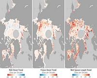
related report How does the Aqua satellite "see" sea ice? Microwaves. Everything on Earth's surface - including people - emits microwave radiation, the properties of which vary with the emitter, thereby allowing the AMSR-E microwave sensor on Aqua to map the planet. Ice emits more microwave radiation than water, making regions of the ocean with floating ice appear much brighter than the open ocean to the AMSR-E sensor. This difference allows the satellite to capture a sea ice record year-round, through cloud cover and the months of polar night. Continuous records are important because sea ice is dynamic. Besides melting and freezing, the ice moves with wind and currents which can cause it to split or pile up. "The data from AMSR-E and other NASA satellites are critical for understanding the coupling between sea ice and the ocean and atmosphere," said Tom Wagner, Cryosphere program manager at NASA Headquarters in Washington. "It's important for us to understand these connections to improve our predictive models of how the planet will change." The Arctic sea ice is a major factor in the global climate system. The ice cools the planet by reflecting sunlight back into space. It also helps drive ocean circulation by converting the warm Pacific water that flows into the Arctic into the cold, saltier water that empties into the Atlantic. The sea ice also fundamentally shapes the Arctic; defining the organisms that make up its ecosystem and keeping heat from the ocean from melting the frozen tundra. In fall 2009, Arctic sea ice reached its minimum extent on about Sept. 12, and was the third lowest since satellite microwave measurements were first made in 1979. Researchers are interested in year-to-year changes, which can be highly variable, so that scientists need many years, even decades, of data to examine long-term trends. Notably, all of the major minimums have occurred in the last decade, consistent with other NASA research, which shows January 2000 to December 2009 was the warmest decade on record. As the sea ice nears the 2010 minimum later this month, look for images and analysis from NASA and the National Snow and Ice Data Center, in Boulder, Colo.
Share This Article With Planet Earth
Related Links Beyond the Ice Age
 Arctic ice melting quickly, report says
Bremerhaven, Germany (UPI) Sep 13, 2010 The ice around the North Pole has experienced another severe meltdown this year, German scientists said. Around 1.9 million square miles of the Arctic Ocean will be covered by ice by the end of this summer, the third-lowest figure since satellite monitoring began in the 1970s, scientists from the University of Hamburg and the Alfred Wegener Institute for Polar and Marine Research said M ... read more |
|
| The content herein, unless otherwise known to be public domain, are Copyright 1995-2010 - SpaceDaily. AFP and UPI Wire Stories are copyright Agence France-Presse and United Press International. ESA Portal Reports are copyright European Space Agency. All NASA sourced material is public domain. Additional copyrights may apply in whole or part to other bona fide parties. Advertising does not imply endorsement,agreement or approval of any opinions, statements or information provided by SpaceDaily on any Web page published or hosted by SpaceDaily. Privacy Statement |


 del.icio.us
 Digg
Digg Reddit
 YahooMyWeb
 Google